


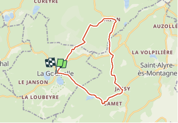
la Godivelle Brion Jassy

mrcat
User

Length
14.6 km

Max alt
1272 m

Uphill gradient
311 m
Km-Effort
18.8 km

Min alt
1155 m

Downhill gradient
324 m
Boucle
Yes
Creation date :
2021-07-12 07:54:59.543
Updated on :
2021-07-12 10:54:37.963
2h58
Difficulty : Medium

FREE GPS app for hiking
 SityTrail
IGN / Geographical institutes
SityTrail Plus
The world is yours!
About
Trail Walking of 14.6 km to be discovered at Auvergne-Rhône-Alpes, Puy-de-Dôme, La Godivelle. This trail is proposed by mrcat.
Positioning
Country:
France
Region :
Auvergne-Rhône-Alpes
Department/Province :
Puy-de-Dôme
Municipality :
La Godivelle
Location:
Unknown
Start:(Dec)
Start:(UTM)
493902 ; 5026046 (31T) N.
Comments